Your Christmas weather forecast: Record warmth in Midwest, blizzard conditions in Heartland

From a warm Christmas in the Midwest to blizzard warnings in the Heartland and rain on the West Coast, here's what you need to know for your holiday weather forecast.
Christmas warmth
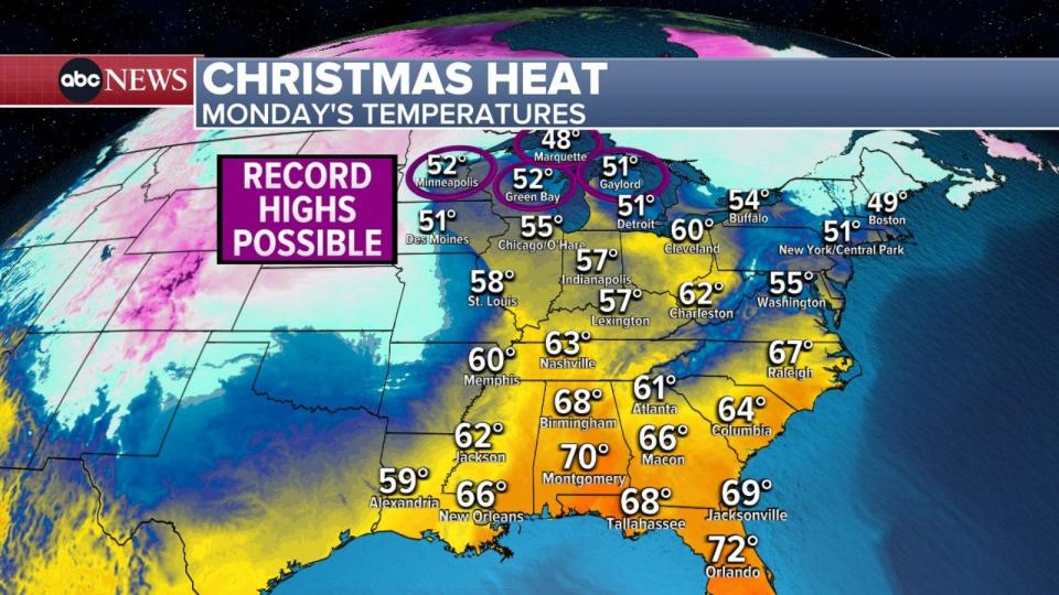
It's a rare warm Christmas in the Midwest.
On Christmas Eve, Minneapolis reached a record high of 55 degrees, while Green Bay, Wisconsin, saw a record high of 52 degrees.
Even in International Falls, Minnesota, along the Canadian border, where the normal high is 18 degrees, the Christmas Eve temperature climbed to a record 47 degrees.
MORE: Christmas travel tips: Best and worst days to fly or drive
More record heat is expected on Christmas Day. Minneapolis and Green Bay are both forecast to have a balmy 52-degree Christmas.
Some of this mild weather will move to the East Coast, with temperatures in the 60s in the South and the 50s in the Northeast.
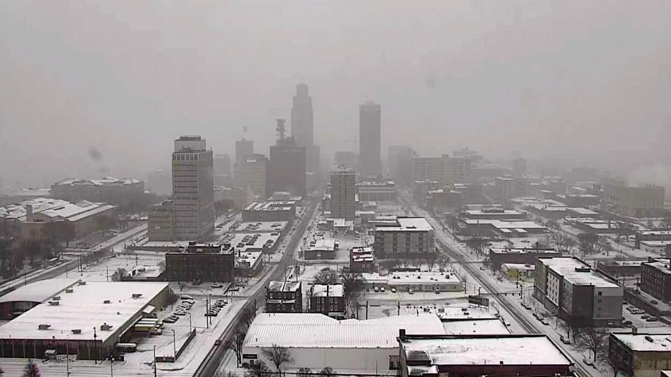
Blizzard conditions in the Heartland
Travel in the Heartland will become impossible later on Christmas Day as a winter storm pummels the region with ice and blizzard conditions.
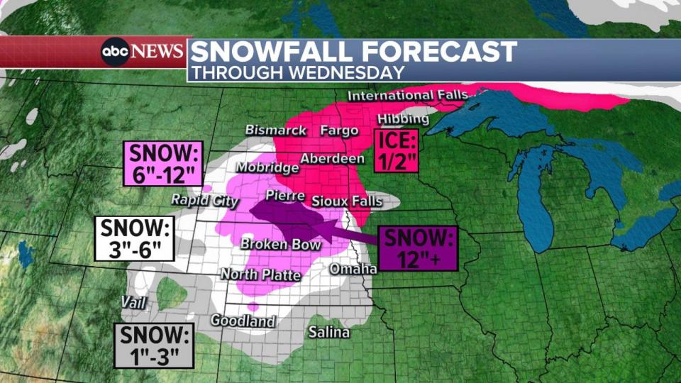
Blizzard warnings were issued in Colorado, Kansas, Nebraska and South Dakota. Heavy snow and wind gusts up to 55 mph are expected.
The storm is causing issues on the roads on this Christmas morning. Slick driving conditions and blowing snow continue in many areas of the state.
These photos are all from between Grand Island and Lincoln on I-80.
Great day to stay inside if travel isn’t necessary. pic.twitter.com/TjmckTcEI1
— Nebraska State Patrol (@NEStatePatrol) December 25, 2023
Most of Nebraska is waking up to a White Christmas, but the wind is howling and blowing the snow.
A Blizzard Warning is in effect for most of the state. Travel is not recommended.
If you must travel, take it slow and be prepared for difficult driving conditions. pic.twitter.com/XYgBy9tl2L
— Nebraska State Patrol (@NEStatePatrol) December 25, 2023
Snow could top 1 foot in South Dakota and Nebraska.
Ice storm warnings and ice alerts were issued in Minnesota, Iowa, North Dakota and South Dakota. Some areas could see up to half an inch of ice accumulation on trees and power lines.
This massive winter storm is expected to last through Tuesday night.
MORE: What every motorist needs to know about driving in snow
Rain in South and Northeast
Thunderstorms will hit Georgia, South Carolina and North Carolina on Christmas night. Up to 4 inches of rain and flash flooding are possible.
By Tuesday evening, the storm will move up the coast, bringing heavy rain to the mid-Atlantic.
On Wednesday, the heavy rain will reach Washington, D.C., New York City and Boston. Some minor flash flooding is possible on the roads.
West Coast forecast
Washington state and Oregon will see rain on Christmas Day. A flood watch was issued for western Washington, where heavy rain could cause some river flooding.
A second storm will arrive Tuesday night into Wednesday morning, bringing heavy rain to the San Francisco area.
Over the next three days, some areas in Washington could see more than 4 inches of rain while Northern California could get up to 3 inches of rain.
Your Christmas weather forecast: Record warmth in Midwest, blizzard conditions in Heartland originally appeared on abcnews.go.com

