Bryan Norcross: Atlantic system organizing as it approaches North Florida while we keep an eye on the Gulf
Updated Friday 9:20 a.m. ET
The center of a small area of low pressure – officially Invest 92L – will move across the coast near the Florida/Georgia border later today. Hurricane Hunters are investigating the system this morning and finding it very close to tropical depression or weak tropical storm status. There is a pronounced center in an area of light winds. The only organized thunderstorms are in an arced band well away from the center.
Whether it's organized enough to be officially designated a depression is somewhat subjective. If the system does get organized, and the aircraft finds winds of 40 mph that the Hurricane Center forecasters are convinced are not just transient, it would be named Tropical Storm Beryl.

In any case, even if it is named a depression to a weak tropical storm before making landfall, the weather impacts won't change.
A round of gusty tropical downpours will stream in off the ocean near and well north of where the center of the system tracks. Wind should hold around 20 mph from North Florida to South Carolina, but gusts to around 30 mph are possible in the cells with heavy rain. Surf will be quite rough in the areas with onshore winds.
There's a cluster of thunderstorms south of the center, not entirely related to the circulation of the tropical system that will produce heavy rain and some gusty winds as well.
The breeze should already be lighter by this evening as the low-pressure system dissipates over the peninsula, although the moisture will linger, so thunderstorms are still in the forecast. While the circulation is over the ocean, the air is being squeezed between the heat-dome high-pressure to the north and the small low-pressure center. That squeeze play is responsible for the gusty breeze blowing off the ocean.
Watching the Gulf: It looks likely that the next tropical system will develop in the southern Gulf of Mexico over the weekend. The mechanism that created Alberto is still in place. A weak disturbance and moisture surge from the Caribbean is pulled north into the Gulf by a large low-pressure system over Central America. Under conducive atmospheric conditions, a tropical depression or tropical storm can organize in the extreme southern Gulf, where the curved coastline aids the development of a circulation.
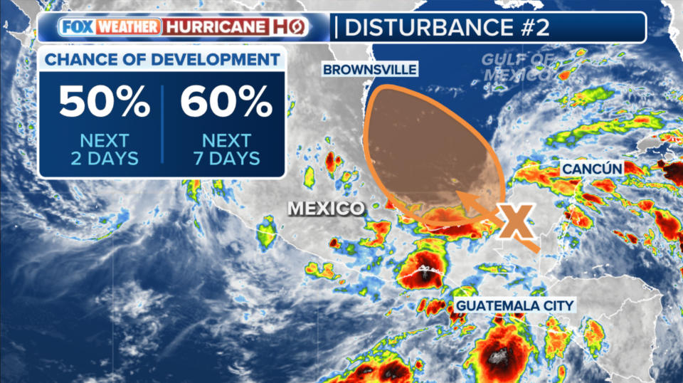
The National Hurricane Center is giving this system a good chance of organizing into at least a tropical depression. Like with Alberto, it appears that the circulation will be quite broad, which usually means strengthening comes slowly. The various forecast models show it tracking over the Gulf for two days or less, so the current thinking is that the system will not have time to get as strong as Tropical Storm Alberto. It might never reach tropical-storm strength. A strong high-pressure system across the southern US should block any movement to the north toward the US Gulf coast.
Whatever the strength, heavy rain is likely next week in parts of northeastern Mexico. Most of the country has been experiencing a serious drought, so rain is welcome. Although areas around the large city of Monterrey, just south of Laredo, Texas, got too much rain all at once from Tropical Storm Alberto.
Onshore winds and tropical rains may well affect South Texas once again, but not at the intensity they saw with Alberto - assuming the computer forecasts are correct, and the system doesn't strengthen in any dramatic way, which looks unlikely.
It's important to remember that forecasts for systems that have not yet developed are always subject to change, so we'll keep that in mind.
Nothing is showing up in the long-range forecasts to be concerned about. So once these systems are inland, we should be calm for a while.
Original article source: Bryan Norcross: Atlantic system organizing as it approaches North Florida while we keep an eye on the Gulf

