Bryan Norcross: Warnings are issued for possible Tropical Storm Alberto in the Gulf
Winds over 40 mph are already blowing across the Gulf of Mexico. If the system in the southern Gulf can develop a well-defined center, the low-pressure area will be named Tropical Storm Alberto, but it has a lot of consolidating to do. Currently, the center of the giant circulation is just a broad area with light winds. It’s hard to even tell where the center is.
The National Hurricane Center has designated this system Potential Tropical Cyclone One, for now. The word "cyclone" is confusing every time this naming convention comes around. Substitute the word "threat," and it's clear - the system is a potential tropical threat.
This low is the same super-broad area of low pressure that straddled Central America for days. Now, it has eased north into the Gulf. Normally, it takes quite a while for big lumbering systems to tighten up a smaller circulation. In this case, however, there is an embedded swirl that might take over and hasten the process. The swirl is what's left of a weak disturbance that moved across the Caribbean.
This situation is an extreme case of the cone being almost wholly disassociated from the worst weather. Whether this system consolidates or not, the impact zone will extend hundreds of miles north of the cone across northern Mexico and Texas. Even Louisiana may feel the effects.
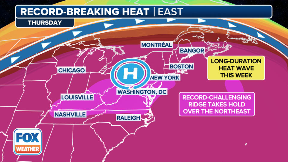
The strong winds across the northern and central Gulf are caused by the air being squeezed between the low pressure of potential Alberto and the heat-dome high-pressure system over the Northeast US. The blocking effect of the high will also deflect the center of potential Alberto toward the Mexican coast and limit how far north it can get. The high heat risk in the Midwest and Northeast shows the effects of the heat-dome high there.
Waves of tropical rain will begin Tuesday on the Texas coast. As we saw in South Florida just over a week ago, the flooding doesn't start right away. Then all of a sudden, blam! Stay aware in all of coastal Texas including metro Houston. South Texas has an "advantage" because it's been in drought. There is more room for the water to soak in, but flash flooding is still possible.
Storm surge is likely at the coast. The strong and persistent onshore winds are pushing Gulf water against the shoreline. The forecast is for the surge to reach up to 4 feet above normal high tide level in some areas, especially in bays and harbors open to the Gulf. Coastal and marine interests should stay informed and take action.
Impacts from potential Alberto are forecast to peak Wednesday into Thursday, and let up by Thursday evening.
Unfortunately, there is increasing computer-forecast consensus that some version of this scenario will repeat itself over the weekend. By then, the heat-dome high will have changed configuration into the Atlantic, so the steering pattern could be different.
The National Hurricane Center has introduced a potential development area in the southern Gulf. The chances of development are in the low category for now, but it’s early in the process, and there is always a lot of uncertainty.
Don't look at any particular computer forecast at this point. There is no system to follow yet, and there may never be. But everyone in coastal Texas, Louisiana, and Mississippi should plan to stay in touch with the forecasts later in the week.
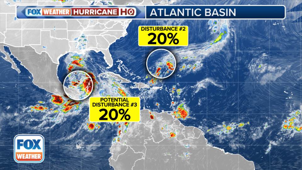
We’re calling this possible Gulf system Potential Disturbance #3.
In the Atlantic, a low-pressure area is still trying to develop from the old front that was part of the Florida deluge – Disturbance #2. There is no indication it could get very strong, and it might not even be tropical. But the steering flow around the heat-dome high-pressure system to the north should eventually push it toward Florida or the Southeast coast.
Whatever form it takes, it's forecast to arrive at the coast about Friday. The National Hurricane Center gives it a low chance of developing into any kind of system with tropical characteristics.
When extreme and unusual weather systems like the heat-dome high develop, quite often unusual things happen around the periphery. So we'll watch closely the developments in the Gulf of Mexico.
Original article source: Bryan Norcross: Warnings are issued for possible Tropical Storm Alberto in the Gulf

