Eastern heat wave, West cool conditions to trade places before end of June


Changes are in the works for the weather for much of the northeastern and western United States that started this past weekend and will be in full swing as this week progresses, AccuWeather meteorologists say. Heat will move out of much of the Northeast but will spring up in the West.
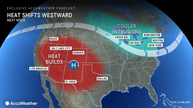
A massive area of high pressure that has been centered over the Mississippi, Ohio and Tennessee valleys much of this past week will shift westward through Sunday and will set up over the Southwest states this week.
 |
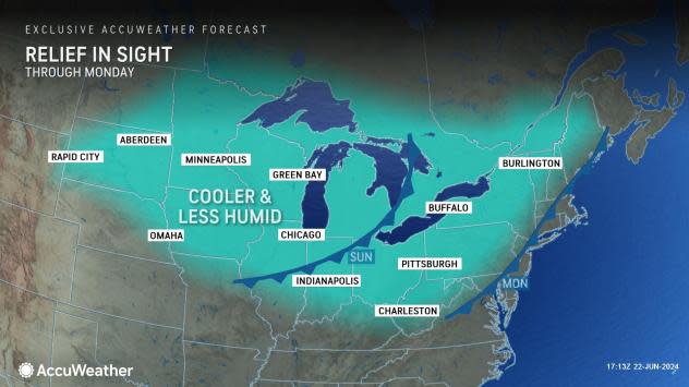
As the change occurs, the jet stream will dip southward over the Northeast and Midwest, and that will pave the way for rounds of cooler and less humid air.
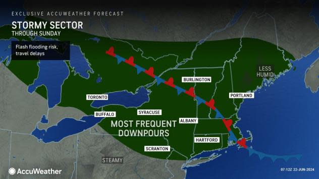
"This change in the pattern will first lead to an increase in thunderstorm activity across the Northeast and Midwest regions," AccuWeather Senior Meteorologist Brett Anderson explained, "Cooler air will first dip into New England while the worst of the heat gets squeezed into the Middle Atlantic and Southeast."
 |
Anderson noted that the meaning of cooler and less humid air in this context only refers to conditions more typical of the historical average for late June and not a return of the unseasonable chill that occurred during parts of the spring.
The pattern flip may be a bit of a shock to those who have become accustomed to sweltering humidity and temperatures of 10-20 degrees above the historical average for much of the past week. For millions of others, the change may feel refreshing, if not a substantial relief, especially for those who do not have air conditioning or access to beaches or pools.
 |
Thunderstorms helped to break the heat in parts of New England on Thursday. Following highs in the upper 90s F in Boston on Wednesday and Thursday, high temperatures reached the low 80s in Beantown on Friday and even the low 70s on Saturday.
However, two main cool fronts will direct more widespread changes to typical late-June conditions in the Midwest and the Northeast.
 |
"One front will slice southeastward from the Upper Midwest to the mid-Atlantic and New England coast into early week," AccuWeather Senior Long-Range Meteorologist Joe Lundberg said, adding, "A stronger front will progress southeastward from the early to the middle part of this week."
The stronger push of cool air will be preceded and accompanied by locally severe thunderstorms from the Midwest to the East.
Temperatures and humidity are forecast to surge briefly to high levels ahead of both fronts then dip in their wake. High temperatures reached the triple digits in Baltimore and Washington, D.C., on Saturday and are forecast to again on Sunday and Wednesday, then trend downward into the upper 80s later in the week. By Thursday and Friday of next week, high temperatures will be in the low to middle 80s in New York City and the upper 70s in Pittsburgh.
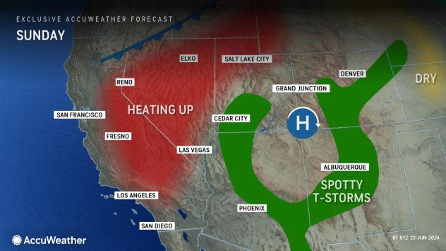
"The core of the heat will become re-established from the southern Plains to the deserts and Great Basin of the West this week, similar to where it was earlier in June," Anderson said.
Some parts of the interior West, such as around Fresno, California, started challenging records on Saturday.
 |
Other cities, such as Las Vegas, may approach record highs by the middle of this week, with temperatures hitting 110 F or more.
The high pressure area may not be strong enough to prevent the daily eruption of spotty thunderstorms over the interior West. Where little rain falls from the storms, lightning strikes could spark new wildfires.
 |
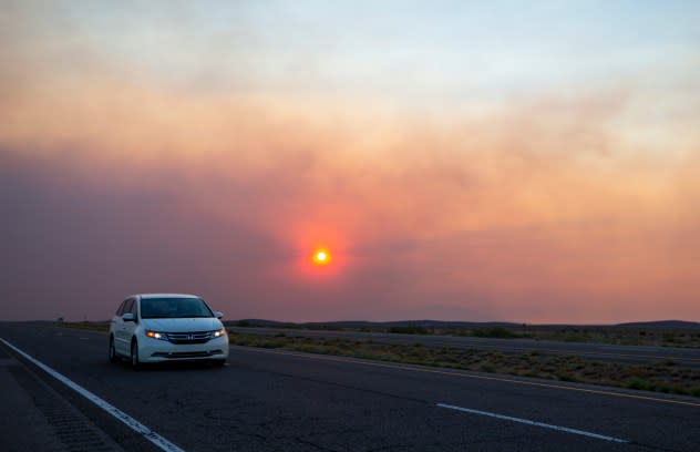
A car rides on the road to Roswell, N.M., as smoke from a wildfire partially blocks the sun near the village of Ruidoso, New Mexico, Tuesday, June 18, 2024. Thousands of southern New Mexico residents fled the mountainous village as a wind-whipped wildfire tore through homes and other buildings. (AP Photo/Andres Leighton) |
According to the National Interagency Fire Center, wildfires were active on Saturday in California, Utah, Arizona, New Mexico and Colorado. Fires in the Ruidoso, New Mexico, area alone have killed at least two people, forced the evacuation of 8,000 people and burned at least 1,400 structures.
Meanwhile, isolated torrential downpours can lead to highly localized flash flooding, especially in some of the arroyos in New Mexico and Arizona.
As the weather changes in the Northeast and the West in the coming days, people in the Southeast region are unlikely to experience much change. Most days will remain hot and humid. Some cooler nights and slightly lower humidity levels may be felt in the southern Appalachians and Piedmont areas for a day or two.
Want next-level safety, ad-free? Unlock advanced, hyperlocal severe weather alerts when you subscribe to Premium+ on the AccuWeather app. AccuWeather Alerts™ are prompted by our expert meteorologists who monitor and analyze dangerous weather risks 24/7 to keep you and your family safer.
