Feel like summer yet? Savannah's heat index could reach 110 degrees, forecasters say
Summer is not letting its 2024 premier go unnoticed.
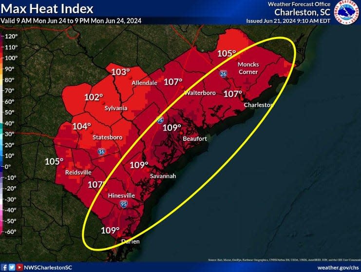
After potential storms over the weekend, heat-index readings approaching 110 degrees are possible beginning Monday in the Savannah area and the South Carolina Lowcountry, forecasters warned Friday.
Outer bands from a tropical system off the coast of Florida brought intermittent showers to the Georgia coast Friday afternoon.
“The circulation and deep moisture associated with the tropical disturbance is expected to linger in the area,” the National Weather Service said.
Savannah faces a 60% chance of showers and thunderstorms Saturday and Sunday with high temperatures of about 90.
Persistent moisture and warmer conditions are expected to make Monday through Wednesday especially uncomfortable. Heat index readings of 105-110 degrees are possible from Savannah to Darien, according to NWS.
Areas closest to the ocean will likely feel the warmest.
“Higher heat indices typically occur across the coastal counties as higher levels of humidity are often found here during the afternoon,” said Steven Taylor from the NWS Charleston office. “Farther inland, humidity levels tend to be a bit lower.”
There also is a 30% to 40% chance of rain and storms Monday through Wednesday.
Severe weather is not expected in the coming days, NWS said.
John Deem covers climate change and the environment in coastal Georgia. He can be reached at 912-652-0213.
This article originally appeared on Savannah Morning News: Savannah faces 110-degree heat index, National Weather Service says

