First weekend of summer brings first rain chance in a while while staying hot
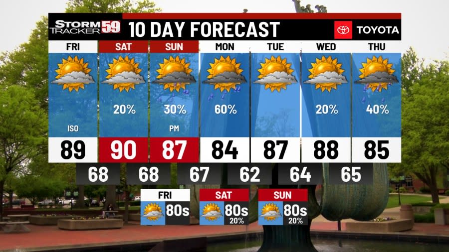
Friday starts cool but it doesn’t take long to warm up. Sunrise around 6am temps hover in the mid 60s but we’ll be in the 80s by lunchtime. Another day where our western counties push 90 and our eastern mountains tap the mid 80s.

Winds begin a more westerly push allow a bump in afternoon highs before humidity induced clouds start building. A stray shower chance for the mountains but again, not enough to ruin your outdoor plans. Overnight lows dip back into the mid and upper 60s.

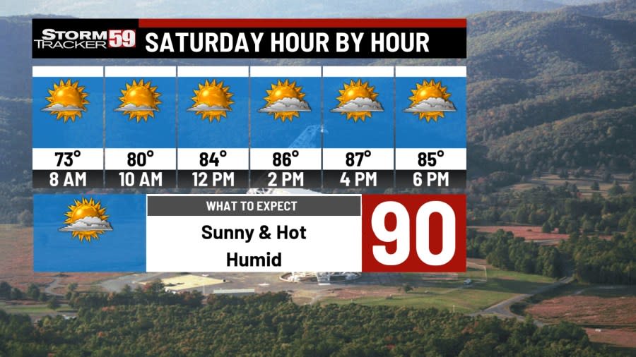
Saturday a cold front starts to take shape through the Heartland of the country. We’ll see high level clouds around but not enough to hurt temps. We’ll once again make a run at 90 degrees but many will fall short with afternoon haze and cloud cover. A stray shower chance for everyone is possible as our front pushes warmer and more humid air back into the region. We’re dry for the overnight with lows in the mid and upper 60s.
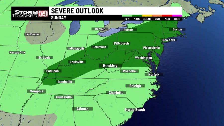
Sunday begins dry with sunshine as temps warm back into the upper 80s. By the afternoon, clouds increase as our cold front inches closer. Sct. showers and afternoon rumbles of thunder are expected ahead of our cold front. By the evening hours, wind pick up 10-15mph as thunderstorms get going.

One or two storms could be on the strong side with damaging winds and hail as the main concern. Our severe weather risk is low, but it’ll be a good day to watch as our cold front marches east into the night.
Monday showers for the morning hours with a few rumbles of thunder by lunchtime. Cooler air is on the way so temps won’t rise as quickly as the previous week. Highs still manage the low to mid 80s as clouds break through the day with sunshine returning for the afternoon.
Tuesday brings an end to the short relief from the heat and humidity as both surge back into the region. Highs once again make a run for 90 degrees for the western counties and mid 80s for the eastern counties.

Wednesday starts dry and mild with temps rising into the upper 80s with morning and early afternoon sunshine. As heat and humidity build a few scattered showers/t-storms roam west to east ahead of our next system. By the evening hours steady, and often heavy, rains bring much needed rainfall totals to the region. With our ground so compact without rainfall, runoff issues leading to ponding and pooling will be a concern.
Thursday morning is a soggy on as scattered showers move through. We’ll see general clearing through the day as sunshine tries to break through thinning clouds. Highs still manage the mid and upper 80s with a humid feel to the day.
In your extended forecast the summer heat in on with little hints to when it will end. Heat and humidity work together to bring the chance of a few afternoon thunderstorms as the middle of June gets underway. Long range forecasts continue to show we’ll be above seasonal averages in temps but below for rainfall. Sorry gardeners, looks like we’ll be stuck watering our summer crops a little longer.
FRIDAY
Mostly sunny, warm, PM iso showers. Highs near 90 degrees.
SATURDAY
Hot & Humid, sct. showers/storms PM. Highs near 90 degrees.
SUNDAY
Warm & humid start. PM Showers & T-storms. Highs in the mid to upper 80s.
MONDAY
AM showers, slow clearing. PM Sunshine. Highs in the low 80s.
TUESDAY
Sunny, warm, humid. Highs in the upper 80s.
WEDNESDAY
Sun & Clouds, Hot & Humid. Highs in the upper 80s.
THURSDAY
Sunny, Hot, Humid. Highs in the upper 80s / low 90s.
FRIDAY
Sunny & hot. Highs in the upper 80s.
SATURDAY
Iso showers off an on. Hot. Highs near 90.
SUNDAY
Sct. showers here and there. Highs in the mid to upper 80s.
Copyright 2024 Nexstar Media, Inc. All rights reserved. This material may not be published, broadcast, rewritten, or redistributed.
For the latest news, weather, sports, and streaming video, head to WVNS.

