At least 5 tornadoes, 100 mph winds confirmed Thursday Night
GIBSON CITY, Ill. (WCIA) – At least five tornadoes have been confirmed in McLean and Ford counties after severe storms swept through Thursday Night.
The National Weather Service released their assessment of the damage after spending days in the area determining what damage was caused by straight line downburst winds and what was caused by a tornado.
Chris Geelhart, the Lead Meteorologist at the National Weather Service in Lincoln said that making that determination was tough.
“The survey team relayed it was extremely difficult in some cases to pick out the tornado damage from the overall swath of wind damage,” stated in a message to media and EM partners on Friday. They said they would continue working through the weekend before releasing details.
Finally, Monday Night, the National Weather Service released their survey information. They found five EF1 tornadoes among a widespread swath of wind damage. Below is the reports and information on the tornadoes and the wind damage that occurred.
Lexington Tornadoes (3 EF1s):
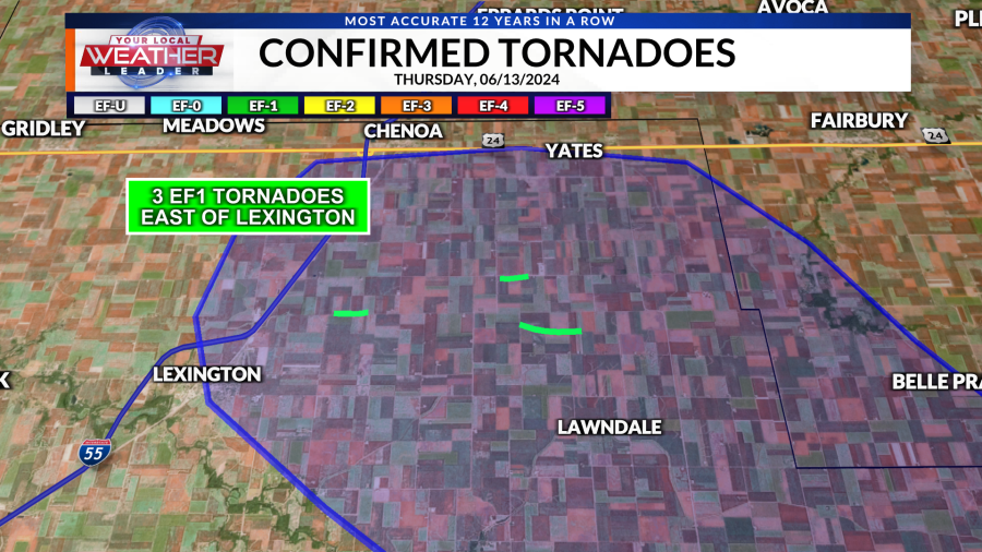
Tornado #1 | 6/13/2024 |
Time (Local) | 8:28 pm CDT |
EF Rating | EF-1 |
Est. Peak Winds | 100 mph |
Path Length | 0.71 miles |
Max Width | 60 yards |
Injuries/Deaths | None |
Summary:A tornado touched down along E. 2600 North Rd. northeast of Lexington, and generally moved eastward. A farm outbuilding lost a significant part of its roof, and a home near the end of the track lost an antenna and a few windows. | |
Tornado #2 | 6/13/2024 |
Time (Local) | 8:29 pm CDT |
EF Rating | EF-1 |
Est. Peak Winds | 110 mph |
Path Length | 0.62 miles |
Max Width | 60 yards |
Injuries/Deaths | None |
Summary:The tornado touched down near the intersection of N. 3050 East Rd and E. 2700 North Rd, moving east and destroying a barn. | |
Tornado #3 | 6/13/2024 |
Time (Local) | 8:31 pm CDT |
EF Rating | EF-1 |
Est. Peak Winds | 100 mph |
Path Length | To be determined |
Max Width | 80 yards |
Injuries/Deaths | None |
Summary:Damage from this tornado was focused in an area between E. 2550 North and E. 2600 North Roads, and generally between N. 3100 East and N. 3300 East Roads. A farm outbuilding lost a significant portion of its roof. | |
Additional damage was surveyed in the Anchor and Colfax areas and determined to be from straight line winds. Due to the intensity of the damage, the National Weather Service estimated some of the damage was caused from 100 mph wind gusts during the storm. A brief EF1 tornado was confirmed southeast of Anchor.
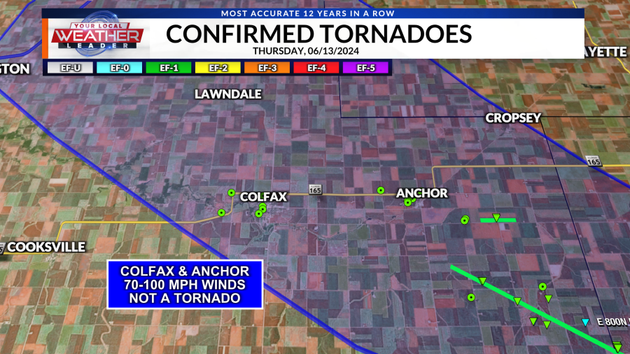
Anchor Tornado | 6/13/2024 |
Time (Local) | 8:45 pm CDT |
EF Rating | EF-1 |
Est. Peak Winds | 110 mph |
Path Length | 0.95 miles |
Max Width | 60 yards |
Injuries/Deaths | None |
Summary:This tornado touched down just north of E. 1900 North Rd., and damaged a farmstead near the intersection with N. 4000 East Rd. A machine shed at this location was destroyed, with debris thrown a half mile east. | |
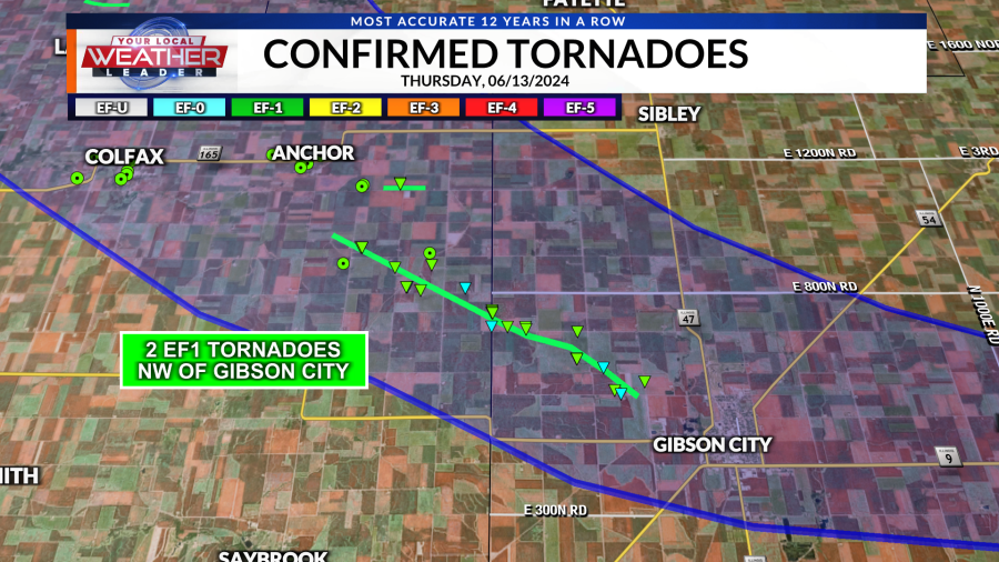
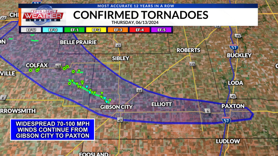
The fifth and final tornado touched down southeast of Anchor and moved southeast towards Gibson City, lifting before reaching town. The widespread extensive winds of 70-100 mph continued past the tornado into the town, causing widespread tree and powerline damage there.
Anchor to Gibson City Tornado: | 6/13/2024 |
Time (Local) | 8:46 to 8:52 pm CDT |
EF Rating | EF-1 |
Est. Peak Winds | 110 mph |
Path Length | 7.64 miles |
Max Width | 1300 yards |
Injuries/Deaths | None |
Summary:This tornado touched down a short distance from another tornado east of Anchor, but moved southeast. Several farm buildings were severely damaged or destroyed along the path. The tornado struck a farmstead at the Ford County line north of E. 1500 North Rd. A home at this location lost a significant part of its roof, and several trees were damaged. It continued southeast before lifting near the edge of Gibson City. | |
After the tornado lifted, the storm continued to produce widespread wind damage up to 100 mph in the Gibson City area. Wind damage was observed, though not as intense, to the east through the towns of Elliott and Paxton before the storm lifted.
To read more about the event, visit the National Weather Service in Lincoln’s page on the storms.
Copyright 2024 Nexstar Media, Inc. All rights reserved. This material may not be published, broadcast, rewritten, or redistributed.
For the latest news, weather, sports, and streaming video, head to WCIA.com.

