Severe storms to rattle Midwest as major river flooding continues


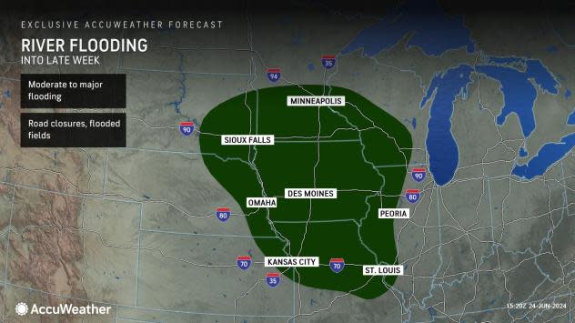
The North Central states have been clobbered by heavy rainfall and locally severe thunderstorms since the middle of June, causing rivers to swell to record territory in some cases. AccuWeather meteorologists say this stormy pattern is set to continue into the end of the month, slowing the recession of floodwaters.
"So much rain has fallen in a zone from southwestern Minnesota to northeastern Nebraska, including northwestern Iowa and southeastern South Dakota, that multiple rivers are on the rampage," AccuWeather Senior Meteorologist Alex Sosnowski said, "Several major rivers in the region, including the Big Sioux and West Fork of the Des Moines rivers, will be in major to record flood stage through early week."
 |
Parts of this region have received a month's worth of rain in two to three days and double the historical average of June rainfall. Sioux Falls, South Dakota, received 6.33 inches of rain in 72 hours from Thursday to Saturday, with 10.8 inches of rain so far in June. This puts June 2024 as the city's second-wettest month on record. The wettest June was in 2014, with 13.70 inches. The historical average rainfall for all of June in the southeastern South Dakota city is 4.23 inches.
AccuWeather meteorologists are tracking several weather features that will sweep across the north-central United States this week and bring additional bouts of heavy rainfall, along with the potential for severe thunderstorms. One of these weather features is a cold front that will bring a reinforcing burst of less humid air in its wake.
The beginning of the week featured severe thunderstorms that moved though Minnesota and Wisconsin as a cold front pushed through the Upper Midwest into Monday night. These thunderstorms brought damaging wind gusts across portions of the region.
"As is the case with any thunderstorm, especially as activity tends to ramp up quickly during the afternoon hours, lightning often poses a significant risk to those spending time outdoors," Sosnowski said. "Experts advise if thunder can be heard, there is a risk of being struck by lightning if outside."
On Saturday afternoon, during a round of severe weather in the Northeast, lightning struck a tree at a home along a golf course in Cromwell, Connecticut. The bolt sent two people to the hospital, according to the Associated Press.
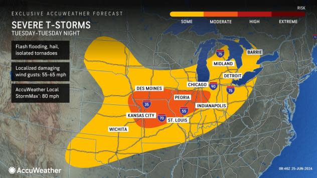
As the front progresses southeastward, the risk of severe thunderstorms will follow suit. On Tuesday, severe thunderstorms can occur at least on a localized basis from part of the Great Lakes region to the central and northern Plains. Chicago and Detroit are among some of the heavily populated metro areas that the thunderstorms could cross.
 |
Locations where clouds and rain start out the day Tuesday, leftover from thunderstorm activity on Monday night, may be at a lesser risk of experiencing a round of damaging thunderstorms later in the day.
The greatest risk for severe thunderstorms around Kansas City, St. Louis and Indianapolis may be later Tuesday into Tuesday night.
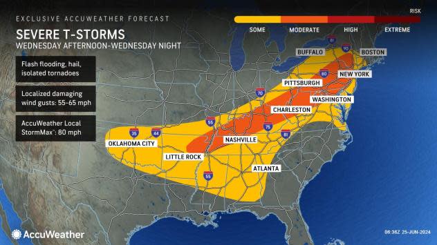
By the middle of the week, the severe weather threat will move mainly into the East and put more than a dozen states at risk of storms packing hail, damaging wind gusts and flooding downpours. The risk of severe weather will increase over the Appalachians during the afternoon and evening. Locally severe storms may survive long enough to approach the I-95 corridor of the Northeast later in the day and at night.
 |
The front's forward progression may slow just enough to create a heightened risk of flash flooding from repeating heavy thunderstorms later Wednesday from part of the upper Ohio Valley to the central Appalachians and New England.
Ahead of the front, there will be a brief rebound in heat and humidity across the Great Lakes and Northeast but it will not have the staying power it has had in recent days.
"Behind this front, an extended stretch of more seasonable heat is anticipated across the Northeast heading into late this week," AccuWeather Meteorologist Brandon Buckingham said.
Meanwhile, AccuWeather experts say that additional rounds of heavy rain and severe weather will sweep across the North Central states later this week and keep river levels running high into the end of the month.
Want next-level safety, ad-free? Unlock advanced, hyperlocal severe weather alerts when you subscribe to Premium+ on the AccuWeather app. AccuWeather Alerts™ are prompted by our expert meteorologists who monitor and analyze dangerous weather risks 24/7 to keep you and your family safer.
