Monsoon 2024: What to expect this year in New Mexico

NEW MEXICO (KRQE) – It’s officially monsoon season in New Mexico. The monsoon season started on June 15 and will continue until September 30. During the monsoon season, states in the southwest see an increase in rain. KRQE’s Chief Meteorologist Grant Tosterud explains what people should expect this monsoon season.
What is the monsoon?
The monsoon is a seasonal change in wind direction. Most of the year, New Mexico and the Southwest experience a dry westerly wind, with occasional storm systems. However, during the summer months, winds become more southerly, drawing up moisture from the Gulf of Mexico and the Pacific Ocean. This change in wind pattern brings increased rainfall and storms to the Southwestern United States, including New Mexico.
What should New Mexicans expect this year?
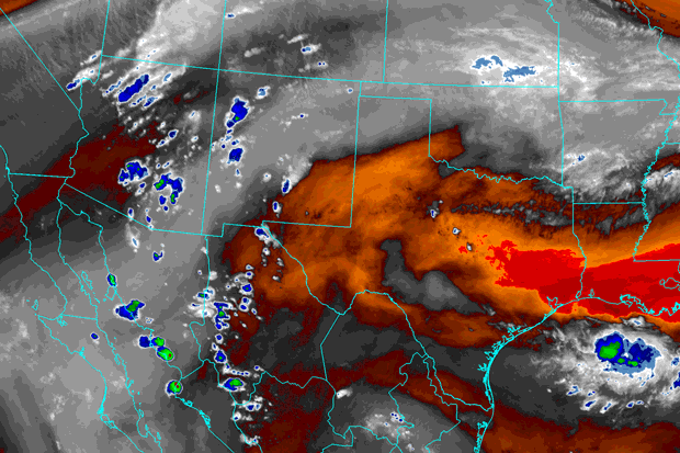
New Mexico has experienced an early surge of monsoon moisture this year. This is thanks to a tropical storm that formed in the Gulf of Mexico and an anomalously strong area of high pressure to our east that has drawn up an early push of moisture into the state. Heavy rainfall and flash flooding have already occurred in parts of the state within the first week of this year’s monsoon season.


While the state is off to a promising start, most climate forecast models agree, we are in store for a hotter and drier-than-average monsoon season.
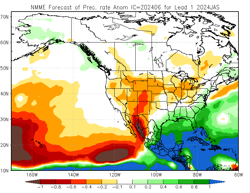

While many climate forecast models and experts at the Climate Prediction Center are forecasting below-average precipitation across New Mexico, this does not mean it will be dry all summer. We will still see surges of monsoon moisture into the state that will bring periods of more active weather and heavy rainfall. What these forecasts tell us is that we will likely see below-average rainfall during this monsoon season, with the highest confidence of below-average rainfall along the New Mexico/Arizona state lineup through the Four Corners.
Looking more closely at climate forecast model data shows an anomalously strong area of high pressure setting up across New Mexico from July through September. This is not unusual at all, in fact, this pattern is called the Four Corners High Pressure. Every year, this high pressure develops in Mexico and migrates northward, eventually setting up over the Four Corners by July. However, the problem is if this area of high pressure is anomalously strong or sits over the Four Corners for too long. That’s what is likely the case this summer.
With multiple climate forecast models agreeing on a drier-than-average monsoon season and the consistency between model runs, most of New Mexico can see a drier-than-average monsoon season.
Will Albuquerque get a big monsoon in 2024?
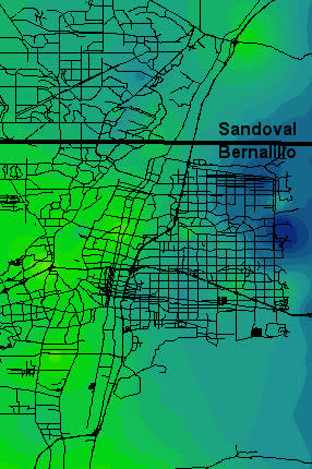
Albuquerque averages 4.61″ of rainfall at the Sunport from June 15 through September 30. This average rainfall can vary widely based on location, with generally higher rainfall amounts the closer you get to the Sandias. It is impossible to say exactly how much rain you will see in your neighborhood, but based on the previously mentioned forecasts, many areas can expect to see below-average precipitation across the Metro. However, it can sometimes take just one storm to push the total rainfall for the season to above average.
What happened last year in Albuquerque?
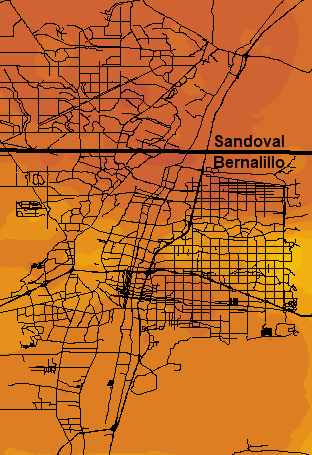
The 2023 monsoon season did not produce much rain for the Albuquerque Metro area. That year ranked as the 10th driest monsoon on record for Albuquerque. In July, few places received more than a quarter inch of rain, according to data from the National Weather Service. During the course of the monsoon season, most locations received between one and four inches of precipitation. According to data, portions of Rio Rancho, Albuquerque North Valley, and the far Northeast Heights were among the areas that struggled to reach the one-inch mark.

However, one of the most memorable days during last year’s monsoon season in the metro was on August 8. On that day, a massive storm pushed huge broken concrete chunks through the arroyo along I-40 and into the San Pedro overpass pillar. The bridge was temporarily shut down due to the incident.
So far, the wettest monsoon on record in the Albuquerque area was in 2006, according to data from the National Centers for Environmental Information. That summer, Albuquerque saw 9.42 inches of rain during the monsoon months — that’s more than double the average.
Copyright 2024 Nexstar Media, Inc. All rights reserved. This material may not be published, broadcast, rewritten, or redistributed.

