More rain in the forecast after flooding cripples parts of South Florida, state of emergency declared
- Oops!Something went wrong.Please try again later.
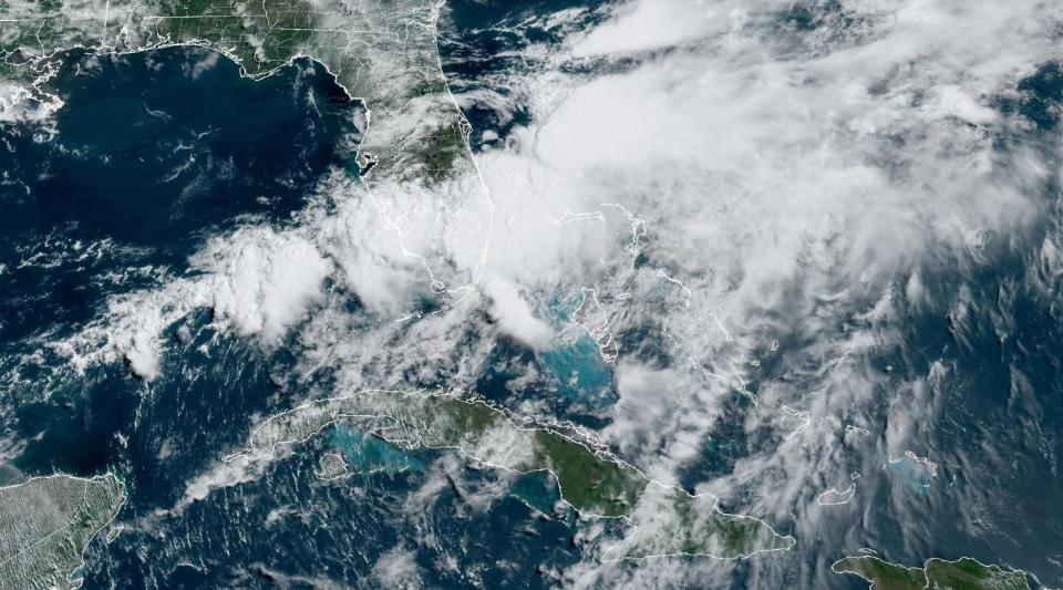
A channel of moist air will continue to tumble over Florida through at least Friday with as much as 8 more inches of rain possible in some areas but especially focused in spots south of Palm Beach County where the worst flooding occurred Wednesday.
National Weather Service meteorologists in Miami said to expect two more days of “multiple rounds of showers and thunderstorms” although chances for tornadoes have lessened.
An EF-1 tornado with winds as high as 95 mph hit Hobe Sound and Jupiter Island on Wednesday, uprooting trees and tossing debris along a 1.7-mile-long swath near Bridge Road, according to the NWS office in Melbourne.
Record rainfall wreaks havoc: South Florida experiences "life threatening" flooding, stalled cars, delayed flights
Although no injuries were reported, a pick-up truck was pushed onto railroad tracks along Dixie Highway, Jupiter Island was briefly inaccessible, and Hobe Sound Elementary School temporarily lost power, according to TC Palm.
Near Bridge Road, David Anderson's home suffered damage that included a blown-in garage door and the roof collapsed.
“It's leaking all over the place," TC Palm quotes Anderson as saying. "It destroyed the whole nursery behind us."
The highest rainfall amounts in Palm Beach County from early Tuesday through Thursday morning were measured northeast of Lion Country Safari in Loxahatchee with 9.5 inches tallied by the NWS.
Other areas with high rainfall included Boca Raton (7.65 inches), Delray Beach (6.86 inches), Lantana (6.25 inches), Wellington (5.93 inches), West Palm Beach (5.09 inches), Lake Worth (5.04 inches), Jupiter (4.81 inches) and Palm Beach Gardens (4.49 inches).
In Broward County, the highest rainfall was in Hallandale Beach, where 19.39 inches of rain fell in about a 48-hour period through early Thursday.
"In this situation, conditions may deteriorate quickly," said NWS Miami meteorologist Tony Reynes on Thursday. "There may be some sunshine this morning but it can change. We want to keep a very close eye on the vulnerable areas over the next 24 hours."
Fort Lauderdale-Hollywood International Airport was open Thursday morning but travelers were asked to check with their airlines for flight updates.
“Our terminal and airport exit roadways are clear,” the airport said on social media, noting, however, that a section of East Perimeter Road was closed because of flooding.
The heavy rainfall and flooding triggered a state of emergency declaration by Gov. Ron DeSantis for Broward, Collier, Lee, Miami-Dade and Sarasota counties. DeSantis also ordered the Florida National Guard and Florida State Guard activated "as needed."
The declaration frees agencies from red tape in responding to the emergency and allows local governments to access money in the state's Emergency Preparedness and Response Fund.
2024 hurricane season: 5 tips to stay sane and safe in face of frightful forecast

Through Thursday morning, State Farm reported it had already received about 300 auto claims associated with the torrential downpours.
FOX Weather hurricane specialist Bryan Norcross likened the weather pattern over Florida to the atmospheric rivers that are common along the west coast of the United States.
“It's a relatively narrow band of moisture squeezed between two competing weather systems,” Norcross said in his Hurricane Intel blog. “The warmer-than-normal waters to the south are undoubtedly enhancing the amount of moisture flowing over South Florida.”
The National Hurricane Center is watching two areas for potential tropical development. An area of low pressure that is helping pull moisture into the state is now in the Atlantic Ocean off the east coast of Florida. It has a 20% chance of becoming a named storm over the next two days.
A second area of low pressure in the Bay of Campeche is expected to form this weekend or early next week and has a 40% chance of becoming a tropical cyclone.
The first two names on the 2024 hurricane list are Alberto and Beryl.
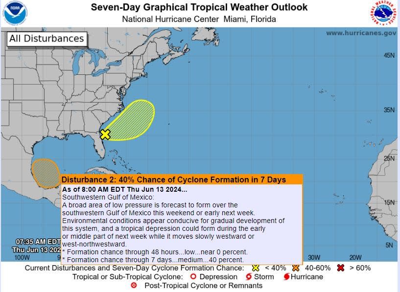
At this point, AccuWeather lead hurricane forecaster Alex DaSilva said he doesn’t expect the spot in the Bay of Campeche to impact Florida. He said it’s more likely going to cause heavy rain in Mexico and possibly in Texas as far north as Houston.
DaSilva said in addition to record warm sea surface temperatures, the depth of the ocean heat in the Gulf of Mexico is concerning. When water is deeply warm, it means a tropical cyclone won’t churn up cooler water from below which can limit its growth.
“In the western Caribbean, there are areas right now where the 80-degree temperature line extends as deep as 300 to 400 feet below the surface,” DaSilva said. “That is something we would expect to see in August.”
Tropical cyclones generally need water temperatures of 80 degrees or higher to form.
Kimberly Miller is a journalist for The Palm Beach Post, part of the USA Today Network of Florida. She covers real estate and how growth affects South Florida's environment. Subscribe to The Dirt for a weekly real estate roundup. If you have news tips, please send them to kmiller@pbpost.com. Help support our local journalism, subscribe today.
TC Palm reporter Will Greenlee contributed to this story.
This article originally appeared on Palm Beach Post: State of emergency declared with more rain expected in South Florida

