National Hurricane Center watching system in Gulf; disturbance near Florida to dissipate
The National Hurricane Center is watching an area of low pressure forecasters say has conditions that are conducive to formation in the next two to seven days.
As of the NHC's 8 a.m. Saturday advisory, the system was over the Bay of Campeche, and moving slowly northwestward.
"Interests along the Gulf coast of Mexico should monitor the progress of this system. This system has a medium chance of tropical cyclone formation through 48 hours and in 7 days," forecasters wrote in their morning weather discussion.
Invest 92L is was closer to the Georgia coast Saturday morning and the National Hurricane Center described what it's become as a low pressure system centered inland over southeastern Georgia, producing disorganized showers and thunderstorms, mainly over the coastal waters off of northeastern Florida and Georgia. The low is expected to drift slowly northwestward or northward before dissipating Saturday night with no tropical cyclone formation expected.
.
In the southwestern Gulf of Mexico, environmental conditions appear favorable for a tropical depression to develop over the weekend or into next week.
➤ WeatherTiger on Invest 92L: Impacts on Florida will be little different than a typical day in June
The next named storm of the 2024 Atlantic hurricane season will be Beryl.
The biggest impacts have come with the loss of life of now five swimmers off Florida waters, two in the Atlantic Ocean Thursday off Stuart Beach. In that incident it was parents with six children who drowned. On Friday night, three men drowned off Panama City Beach.
Rip currents are suspected of being the main culprits in the drownings.
What is a rip current?
Rip currents are powerful, concentrated channels of water flowing quickly away from shore, most often found at low spots or breaks in the sandbar and near structures such as jetties and piers.
Rip currents form when incoming waves create an underwater sandbar. The waves push more water between the sandbar and the shore until it collapses and the water rushes back to the sea through a narrow gap, where it starts to spread out. But they can be difficult to see when you're in the water as the ocean over them can still be smooth.
Rip currents often form during or after stormy weather but can form on bright, sunny days just as easily since the weather isn't really what's causing them. Rip currents can be found at any beach with waves, at any time.
Tropical weather outlook for Saturday
Here's the latest update from the NHC as of 8 a.m., June 22:
92L impact on Florida: Invest 92L approaching Florida, Georgia. Track system, see possible impacts
Spaghetti models for Invest 92L as it moves toward Georgia
Special note about spaghetti models: Illustrations include an array of forecast tools and models, and not all are created equal. The hurricane center uses only the top four or five highest performing models to help make its forecasts.
➤ Storm sequel on horizon? Alberto targets Texas, 'featherweight' system nears Florida
What else is out there and how likely is it to strengthen?
Southwestern Gulf of Mexico: broad area of low pressure is forecast to form over the Bay of Campeche by this evening.
Environmental conditions appear conducive for gradual development of this system as it moves slowly west-northwestward or northwestward, and a tropical depression could form over the southwestern Gulf of Mexico this weekend.
Residents along the Gulf Coast of Mexico should monitor the progress of this system.
Formation chance through 48 hours: medium, 50 percent.
Formation chance through 7 days: medium, 50 percent.
Who is likely to be impacted?
Low pressure system, the former Invest 92L: Mainly disorganized showers over the coastal areas of Georgia and Florida.
Rip currents will increase in strength and frequency from the east-central coast of Florida to North Carolina.
Southwestern Gulf of Mexico: This system will need to be watched along the Gulf Coast.
Tropical waves: Three tropical waves were being tracked by forecasters in the eastern and central Atlantic, and another in the Caribbean.
Weather watches and warnings issued in Florida
When is the Atlantic hurricane season?
The Atlantic hurricane season runs from June 1 through Nov. 30.
When is the peak of hurricane season?
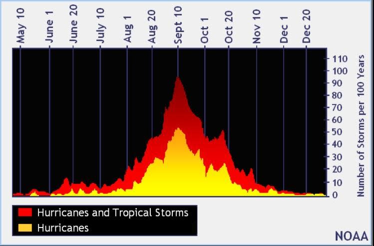
The peak of the season is Sept. 10, with the most activity happening between mid-August and mid-October, according to the Hurricane Center.
National Hurricane Center map: What are forecasters watching now?
Systems currently being monitored by the National Hurricane Center include:
Interactive map: Hurricanes, tropical storms that have passed near your city
Excessive rainfall forecast
What's next?
We will continue to update our tropical weather coverage daily. Download your local site's app to ensure you're always connected to the news. And look for our special subscription offers here.
This article originally appeared on The Daytona Beach News-Journal: NHC forecast suggests Gulf Coast areas keep eye on system

