Odd weather terms you may hear in the spring and summer
Like any science field, meteorology comes with an abundance of technical terms that, quite frankly, only professionals will ever truly need or understand. There are some terms, however, that are commonly used when presenting weather information to the public or terms for phenomena we see regularly that just sound outright made up.
Here are some terms you may hear throughout the spring and summer months that may sound unusual or made up, but are actually real terms:
Haboob
While this may sound like a funny word, haboobs are not to be taken lightly. They are massive and intense dust storms that can rapidly create zero-visibility conditions.
Caused by intense downdrafts from powerful storms, these massive dust storms can often be seen from space. While we don’t see haboobs in Canada, they are a more common occurrence in the southwestern United States, where the North American Deserts are.

A Haboob moving across the landscape near Ransom Canyon, Texas, in 2009. Credit: Leaflet/Wikimedia. CC BY 3.0.
Virga
It’s very possible that you have seen Virga without even realizing it. When looking at Virga from afar, it looks deceptively like a plain, low-hanging cloud. But it’s really much more than that!
Virga occurs when the amount of moisture at the ground surface is very low while the amount of moisture in the atmosphere is still ample. So the moisture-filled clouds will produce rain per normal, but we will never actually see or feel those raindrops at the surface. The surface is so dry that the rain completely evaporates before it ever hits the ground.
So what looks like a low-hanging cloud in the distance is actually a rain cloud!
A picture of #virga, or rain that doesn't reach the ground, taken looking east from our office this morning before #sunrise . #wywx pic.twitter.com/PO5Ky1iiPK
— NWS Riverton (@NWSRiverton) May 31, 2023
Derecho
The term ‘derecho’ may not have been on anybody’s radar until 2022, when a deadly derecho swept across southern Ontario and Quebec, leaving a 1,000-kilometre-long trail of damage in its wake. The storm tragically took the lives of several people caught in its path and damaged many buildings.
Derechos are fast-moving and long-lived storms that produce powerful straight-line winds—upper-level winds that have been forced to the surface and rush forward with no rotation. In Spanish, ‘derecho’ translates to “straight ahead.”
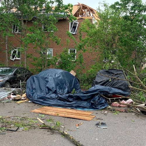
Damage in Uxbridge, Ont., after the May 21, 2022 derecho event that swept across parts of Ontario and Quebec. (Mark Robinson/TWN)
Scud
With so many different types of clouds, it’s no wonder they tend to all have unusual-sounding names. One cloud you may not hear about very often but will make your heart skip a beat when you see it is a scud.
Scuds are probably the cloud-version of “looks scary, but is actually very sweet.” People often mistake them for funnel clouds due to their low-hanging and menacing-looking nature.
In reality, scud, also known as stratus fractus, is caused by high humidity and quick winds underneath a nimbostratus cloud—the cloud one typically associates with a rainy day. As air rises and condenses, it is whisked away with the movement of the parent cloud and forms scary, tendril-like wisps of low-hanging clouds.
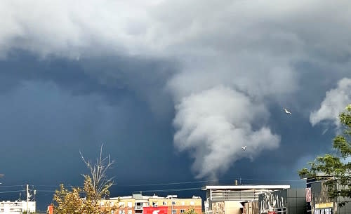
Scud cloud during a thunderstorm in Stoney Creek, Ont. (Submitted by Mark Newby)
Squall line
Squall can be a confusing word in meteorology due to the fact that it means different things depending on the context. For example, if you spend a lot of time on large bodies of water, you may have seen your fair share of squalls—sudden, fast, and gusty winds caused by air moving unobstructed over vast bodies of water, such as the Great Lakes or the oceans.
In the winter, you may have been caught in a snow squall while driving, going from good visibility to sudden near-whiteout conditions as snow violently blows by you.
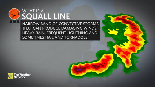
In the spring and summer, you will often hear forecasters talking about squall lines. In this context, a squall line is a line of multiple thunderstorms that moves along a cold front, often producing quick storms with high winds. These are essentially your ‘typical’ spring and summer thunderstorms. They chase and feed on warm air as the cold front ‘chases’ a warm front.
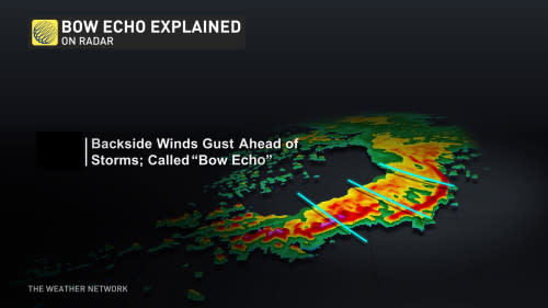
Sometimes, the surface winds associated with a squall line will be strong enough to push part of the line out into a curve. When this happens, meteorologists refer to the curved area as a "bow echo."
Thunderstorms embedded in squall lines are different from supercell thunderstorms in that they are much shorter-lived and are much less likely to have any rotation. That being said, it is still possible for a storm from a squall line to produce a tornado.
QLCS tornado
When storms in a squall line do produce a tornado, it is called a QLCS tornado—a ”quasi-linear convective system” tornado. Essentially, it is just a tornado that was not produced by a supercell.
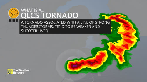
Most of the time, QLCS tornadoes are shorter-lived than supercell tornadoes and are usually less intense. They are still just as dangerous as supercell tornadoes, however, and should never be taken lightly.

