Soaking rains, severe storms target southern Ontario this weekend
An atmosphere packed with high moisture will fuel bountiful rains and threats for thunderstorms across parts of southern and central Ontario through the weekend.
The rain and thunderstorm chances comes on the heels of a multi-day heat event in Ontario and Quebec, with temperatures jumping into the 30s and humidex values pushing passed 40.
MUST SEE: Your changeable Canada Day forecast may turn into a game of musical chairs
Both days will feature rain and the chance of thunderstorms, with a severe weather opportunity in parts of the region on Saturday. Main threats include heavy downpours, gusty winds and large hail. There is also the slight chance of rotating storms for areas south of Georgian Bay and west of the Golden Horseshoe.
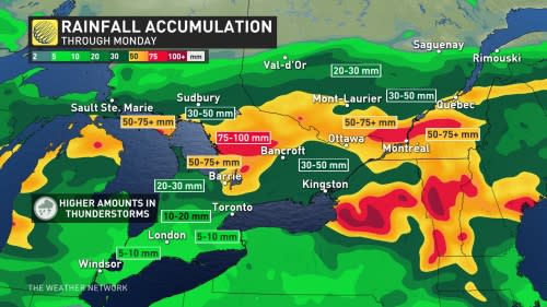
With the amount of rainfall expected in parts of the region through Monday, anywhere from 50-100+ mm, localized flooding will also be a concern.

Remain alert for watches and warnings as you head about your weekend.
Severe storms possible again on Saturday
A low-pressure system will drive the stormy conditions expected across much of Ontario this weekend. The low will move into the Great Lakes into Saturday, forcing multiple rounds of rain to sweep over the province.
Widespread heavy rain is expected throughout central Ontario, while communities in southern and eastern Ontario can expect multiple opportunities for thunderstorms on Saturday and Sunday.
Showers developed throughout central and eastern Ontario on Saturday morning as a warm front moved into the region.
RELATED: Watch? Warning? How we communicate severe weather in Canada
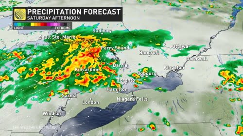
Farther south, expect thunderstorms to develop on Saturday afternoon and roll inland from Lake Huron. There’s still some lingering uncertainty exactly where these storms will develop and track, so factor the risk for rain into any outdoor plans through the day.
WATCH: What to expect as storms flair up Saturday over southern Ontario
A copious amount of atmospheric moisture lumbering over Ontario will provide a vast reservoir for any showers or thunderstorms to tap into this weekend.
Look out for a risk for torrential downpours and strong wind gusts in any thunderstorms that develop. Some areas could see 50-100+ mm of rain through Monday, which could lead to localized flooding in vulnerable areas. For storms that reach severe limits on Saturday, there is also a hail risk.

As well, there is a chance of rotating storms and one or two tornadoes in areas south of Georgian Bay and west of the Golden Horseshoe.
Storm threat continues into Sunday
Our low-pressure system will stick around with unsettled weather to end the weekend. Heavy rains will persist across central Ontario through the day Sunday.
Meanwhile, folks across southern Ontario and the Greater Toronto Area will contend with a cold front swinging into the region on Sunday morning. Showers and thunderstorms will develop along and ahead of this front as it arrives.
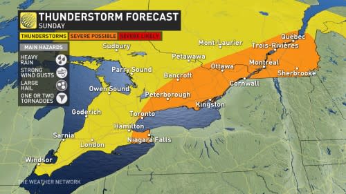
Dynamics are favourable for severe weather across portions of eastern Ontario as the thunderstorms arrive on Sunday afternoon. Keep an eye out for the potential for strong wind gusts, heavy rainfall, and some hail in the stronger storms in the area.
The widespread rain will also reach into Quebec, putting a rainy damper on Saint-Jean-Baptiste Day celebrations.
WATCH: Storms, landspouts roar over southern Ontario on Thursday
*Thumbnail courtesy of Getty Images/Doctor_bass Creative #: 105934727.
Stay tuned to The Weather Network for the latest forecast across Ontario.

