Favourable conditions for tornadoes prompts watches in northwestern Ontario
Severe thunderstorms have popped up in parts of northwestern Ontario Tuesday afternoon, prompting warnings and tornado watches, as well. Storms capable of producing heavy rain, strong winds and large hail target southern Saskatchewan. The threat for tornadoes will persist into the evening hours on Tuesday.
Current tornado watches
Atikokan - Upsala - Quetico
Gull Bay - Black Sturgeon Lake
Atikokan - Upsala - Quetico
Kakabeka Falls - Whitefish Lake - Arrow Lake
5:01 p.m. EDT: Conditions are favourable for the development of severe thunderstorms which may produce tornadoes. Strong winds, large hail and heavy rain are also possible.
Hazards: Tornadoes possible. Wind gusts up to 100 km/h. Torrential downpours. Nickel- to ping pong ball-sized hail.
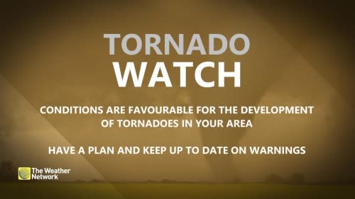
This tornado watch has been upgraded from a severe thunderstorm watch that was previously in effect. A line of thunderstorms is expected to develop this afternoon. Alongside strong wind gusts and torrential downpours, a few tornadoes are possible. For details on rainfall, please see the rainfall warning or special weather statement that is currently in effect. While the probability of nickel- to ping pong ball-sized hail is low, it remains possible.
This is a dangerous and potentially life-threatening situation.
Be prepared for severe weather. Take cover immediately, if threatening weather approaches.
Tuesday: Severe thunderstorms with heavy rain, hail and slight tornado threat
The first round of storms arrived through the overnight hours on Monday, ahead of a warm front and low pressure system. The storms produced a huge area of heavy rain, spanning nearly 400 km at the time.
This is a huge area of moderate to heavy rain in NW ON this morning - nearly 400 km across. Larger than some Canadian provinces (e.g. NB) & many US states (e.g. OH). Have to think there are going to be some flash flooding issues in that area if this keeps up much longer. #ONstorm pic.twitter.com/jUiiEzEPyi
— Dave Sills 🍁 (@dave_sills) June 18, 2024
A second and more potent round of thunderstorms will begin to track in through the mid-afternoon on Tuesday, as the cold front slides across the area.
There will be strong, upper-level support, accompanied by deep moisture and the presence of high atmospheric energy.
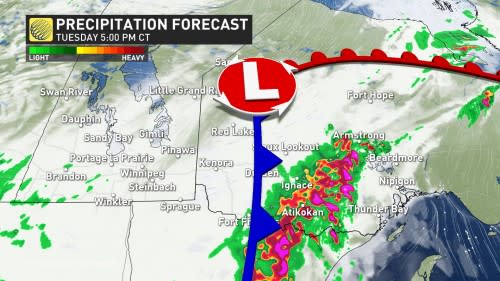
"Areas affected by several storms or a prolonged episode of rain due to the slow movement of certain storms could receive more than 80 mm in places," warns Environment and Climate Change Canada (ECCC) in a special weather statement issued for the region, adding that the precise areas that will receive the heaviest rain remain rather uncertain.
With such heavy rainfall, there is the heightened risk of flooding.
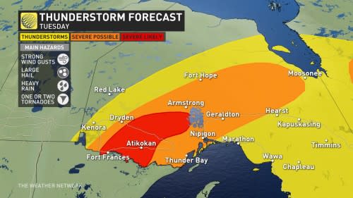
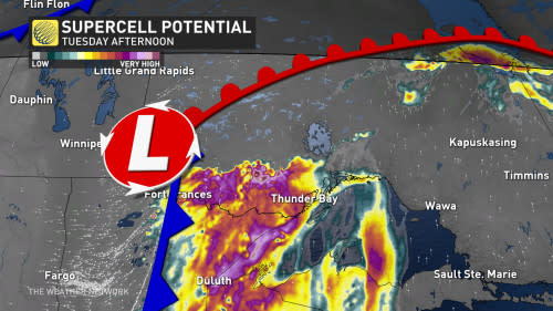
Good wind shear will be also present, providing the final ingredient for the potential for supercell thunderstorms, which include a risk of a tornado.
For those to come to fruition, the critical timing will be between 4 and 9 p.m.
DON'T MISS: What to do if a tornado warning is issued
As such, all severe weather parameters are possible including heavy rain, a localized flood risk, large hail, strong wind gusts, and a tornado risk.
Residents in the risk areas are urged to stay weather-aware, and updated on all of the severe weather watches and warnings throughout the day.
Northern Ontario has already seen its fair share of severe weather this month. An EF-2 tornado was confirmed to have occurred on June 4, northeast of Dryden, making it the first EF-2 tornado of 2024 in Canada. An EF-1 downburst has also been confirmed in Owen Sound on June 13.
MUST SEE: How hail – of all shapes and sizes – forms, falls from sky
WATCH BELOW: Tornado safety tips
Stay tuned to The Weather Network for more weather updates across northern Ontario.

