Showers with stronger thunderstorms possible for Saturday
The Latest Northeast Wisconsin Forecast from Storm Team 5…
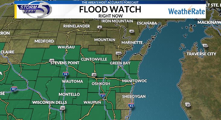
Showers and thunderstorms have entered the area, which is just the start of a wet and damp next 36 hours for Northeast Wisconsin. For the amount of rain we will see, a FLASH FLOOD WATCH is in effect south of HWY 29 until 7pm Saturday, warning for excessive rain resulting in flooding of small water bodies and lower lying areas.
A slow moving warm front is positioned in far southern Wisconsin, bringing the necessary ingredients needed to get showers and thunderstorms going, Nothing severe is expected tonight, but a shower or storm producing a locally strong gust of wind and a heavy downpour is expected.
Now during the overnight hours, the showers and storms will transition from widespread in coverage to a more scattered/on and off variety. Todays rain totals will sit between a quarter and three quarters of an inch, with over 1″ in spot spots. Tonight’s lows will fall into the upper 50s north and low 60s elsewhere.
Saturday morning looks to be a complete washout with showers and thunderstorms bringing soaking rain across the area. Some indications are that there will be breakage in the showers and storms around dinner time, but will be short lived as the cold front will drop in and bring another round of widespread showers and thunderstorms during the evening and early overnight. Highs tomorrow will be in the mid 60s up north and low to mid 70s Green Bay and southward.
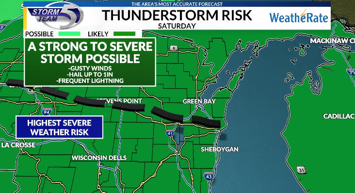
There is a severe weather risk tomorrow, with a thunderstorm producing gusty winds, hail up to 1in and frequent lightning possible. I don’t think it will be widespread, with the best chance of seeing a strong to severe storm being south of Appleton. Not so say a strong storm wont be seen North of Appleton, but our southern counties will see the highest moisture and energy available for storms.
Showers and storms will start to decrease in coverage overnight Saturday as this system pulls away. Watching for some fog to develop if winds go calm enough and some skies clear out. Lows to around 60 degrees.
Sunday will feature decreasing clouds throughout the day, but a weak mid level disturbance will slide across the area, bringing a pop up shower north of Oconto. Highs with the added sunshine will sit in the mid to upper 70s. Monday a full dry day with highs into the low to mid 80s. Next rain chance after Saturday will occur late Monday into Tuesday morning. Humidity will spike and temperatures build into the upper 80s.

Copyright 2024 Nexstar Media, Inc. All rights reserved. This material may not be published, broadcast, rewritten, or redistributed.

