Tropical Rainstorm Alberto pushes inland over Mexico, US impacts ease


Alberto, the first named system in the 2024 Atlantic hurricane season, made landfall around sunrise Thursday morning near Tampico, Mexico, as a tropical storm with maximum sustained winds around 45 miles per hour. Despite being downgraded later Thursday, the system continues to bring torrential downpours over parts of Mexico and southwest Texas as a tropical rainstorm.
Alberto was named on Wednesday morning, June 19, as it tracked across the southwestern Gulf of Mexico. Around daybreak on Thursday, Tropical Storm Alberto moved ashore near Tampico, Mexico, and the storm will continue to advance inland and slowly unwind into Friday. Alberto was downgraded to a tropical depression at mid-morning, while moving to the west at 18 mph and packing sustained winds of 35 mph.
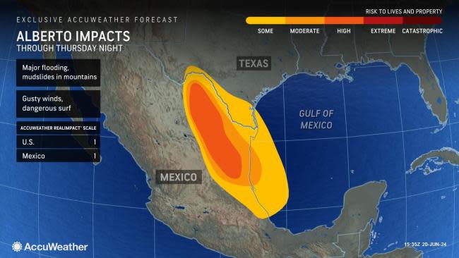
Despite being downgraded, Alberto will still pose a serious threat from excessive rainfall.
 |
"Abnormally warm waters and a pocket of relatively low wind shear located in the Bay of Campeche allowed Alberto to gain enough organization on Wednesday to be upgraded to tropical storm status," explained AccuWeather Meteorologist and Lead Hurricane Forecaster Alex DaSilva.
On average, the first tropical storm forms in the Atlantic Ocean by June 20. With Alberto developing into a tropical storm on June 19, this season is progressing right on schedule. However, other systems being monitored in the short term could quickly escalate into named storms within days.
Heavy coastal rain and flooding are expected to ease in Texas but continue in Mexico through Friday. Already, the heaviest rains have shifted well inland over Mexico while spotty thunderstorm activity lingered near the coast and in South Texas.
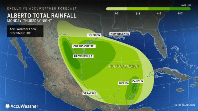
While the bulk of the rain has already fallen on much of southeastern Texas, rainfall totals as high as 8-12 inches can occur over the Big Bend area of Texas and especially in the higher elevations of northern Mexico, where the AccuWeather Local StormMax™ for rainfall is currently set at 30 inches.
 |
With Alberto moving inland and circulation decreasing, the AccuWeather Local StormMax™ for wind gusts is 75 mph and is most likely to occur in strong thunderstorms in northeastern Mexico and southern Texas.
In addition to the threat of strong winds and heavy rain across portions of Mexico and Texas, forecasters warn that mudslides can occur throughout the mountainous terrain of Mexico. Due to impacts across eastern Mexico, the AccuWeather RealImpact™ Scale is set at 1.
 |
Storm surge along the coasts of northeastern Mexico, Texas and western Louisiana has already peaked and generally ranged between 1 to 3 feet. Locations around Houston and Galveston in Texas faced higher levels of storm surge, reaching up to 3 to 6 feet in some low-lying areas. Storm surge and above-normal tides will slowly ease into Friday with the center of Alberto inland and slowly unwinding.
Residents are urged to heed any warnings given by professionals and emergency management personnel. Storm surges can result in extensive damage and be one of the greatest threats to life as a storm impacts a region.
Due to the impacts of storm surge, rain and wind, the AccuWeather RealImpact™ Scale for the United States is 1.
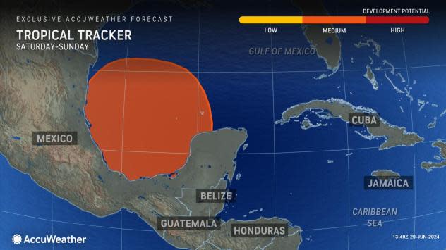
This weekend, another tropical system may ramp up across the Bay of Campeche and Gulf of Mexico. Forecasters say that a "rinse and repeat" of the early to midweek pattern can occur across the northeastern Mexico and South Texas coastlines.
 |
"There is a moderate chance for development from June 21-23 across a similar area in the Gulf of Mexico. This feature will need to be watched for possible impacts on the Gulf coasts of the United States and Mexico this weekend into early next week," explained AccuWeather Meteorologist Andrew Kienzle.
Depending on the intensity and track of this new disturbance, rain, wind, coastal flooding and surf will likely build along much of the Texas and northeastern Mexico coasts again. Where heavy rain from the new system overlaps with rain from Alberto, the risk of flooding will be greatest. However, some exceptions may occur, where downpours focus from the second system on areas that were barely scratched by Alberto.
AccuWeather meteorologists are also closely monitoring an area of disturbed weather east of Florida for tropical development in the coming days.
Want next-level safety, ad-free? Unlock advanced, hyperlocal severe weather alerts when you subscribe to Premium+ on the AccuWeather app. AccuWeather Alerts™ are prompted by our expert meteorologists who monitor and analyze dangerous weather risks 24/7 to keep you and your family safer.
