Triple-digit temps settling across Southern Utah — Here’s what you need to know
WASHINGTON COUNTY (ABC4) – Early season intense heat has arrived in parts of Washington County including Zion National Park, St. George, and near Lake Powell and our first triple-digit day arrived Wednesday, one day behind the average first 100+ day in St. George.
A very broad area of high pressure has built over the western United States resulting in this early-season heat wave. Heat watches and warnings are posted throughout the Desert Southwest, Utah included, as this area of high pressure centers up over Utah today and tracks towards the Four Corners.


The city of St. George typically sees 52 triple-digit days a year, but Thursday’s forecast high will not only break the daily high-temperature record but is also occurring quite early. We typically don’t see highs climb to near 108 degrees until about July 4. This is a notable shift in the Utah weather pattern considering we started the work week with temperatures running below average for most of the state following the passage of a cold front. While St. George hasn’t been cool this week, the low 90s we saw Monday are actually right on target for seasonal norms this year.
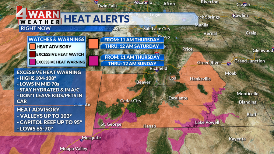
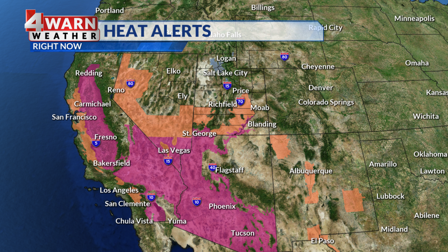
As we approach the hottest day of the next seven, we have several heat alerts going into effect for Southern Utah. We are in good company, with warnings and advisories also peppering Nevada, California, and Arizona. The National Weather Service, the only federal agency that can issue weather warnings and alerts, posted Excessive Heat Warnings and Heat Advisories for several Southern Utah communities.
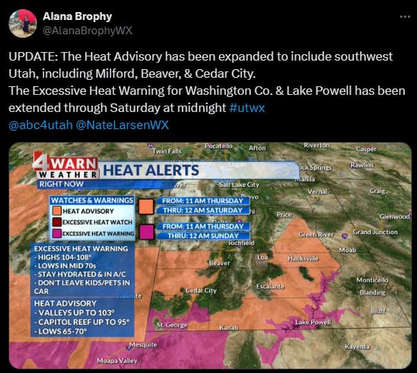
An Excessive Heat Warning impacting lower Washington County, Glen Canyon Recreation Area/Lake Powell, and Zion National Park begins Thursday at 11 am as heat builds from overnight lows that stayed very mild near 70 degrees. Originally, the warning was slated to expire at midnight Friday, but it’s since been extended through midnight Saturday night. As high heat holds on the influence of the ridge continues. Daytime highs can be expected to range from 104-108° which could challenge daily records, especially in the city of St. George. Unfortunately, there won’t be much relief overnight as overnight lows will still be fairly warm in the mid-70s. Typically, criteria for an excessive heat warning means temperatures exceeding 105 degrees for at least two days with overnight lows staying above 75 degrees.
A Heat Advisory also starts at 11 a.m. Thursday and holds through midnight Friday night, now spans from southwest Utah, through the south-central region, and into Castle Country. Cities and parks within the advisory include Cedar City, Milford, Beaver, San Rafael Swell, Capitol Reef, Western Canyonlands, Escalante, Kanab, Green River, Hanksville, Goblin Valley, and Loa. Highs will reach the low 100s in lower valleys while some cooler spots like Capitol Reef, Cedar City, and Beaver will hit the mid to upper 90s.
With extreme heat this early in the season, the National Weather Service warns people may not be acclimated, and we could see a spike in heat-related illnesses as a result. It’s also important to keep the dangers associated with extreme heat in mind. Plan to deal with the heat ahead of time, such as by staying hydrated, wearing light clothing, checking on the elderly or those without adequate cooling, and making sure to never leave children or pets in the car!
The 4Warn Weather Team will continue to monitor conditions and keep you posted on evolving warnings and conditions both on our 4Warn Weather forecast as well as on-air and online, we are Good4Utah!
Copyright 2024 Nexstar Media, Inc. All rights reserved. This material may not be published, broadcast, rewritten, or redistributed.
For the latest news, weather, sports, and streaming video, head to ABC4 Utah.

