Tropical disturbance expected to bring wind, rain to Hilton Head. Cloying heat follows
A tropical disturbance 120 miles east of Jacksonville, Florida, was expected to cause residual effects in the Lowcountry on Friday.
Increasing in the possibility of formation, the disturbance was producing winds near 35 mph mid-morning Friday, according to the National Hurricane Center. It noted that the associated showers and thunderstorms were not “quite organized enough” to deem the system a tropical cyclone.
Even if the system became a short-lived tropical depression, Blair Holloway, a meteorologist with the National Weather Service’s Charleston office, said its impact on the Lowcountry wouldn’t change.
Holloway said possible showers and thunderstorms will move into Beaufort County starting Friday afternoon. Winds gusts could reach up to 25 mph along the coast, according to the service.
With the incoming tropical disturbance, severe weather and flooding are not significant concerns, Holloway said, but high rip current risks will persist.
On Friday, Beaufort County was under a hazardous weather outlook due to rip current risks, according to the NWS.
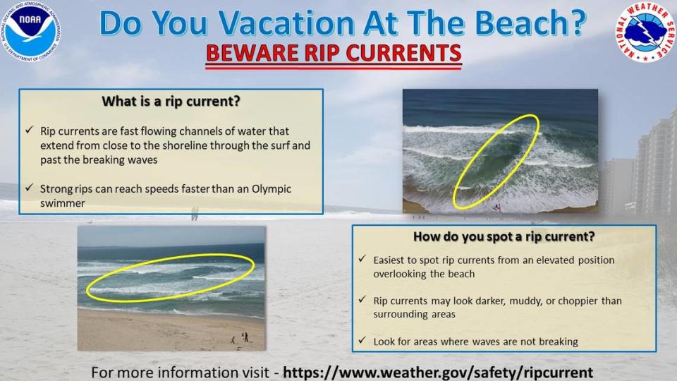
Even for experienced swimmers, rip currents can be life-threatening.
In the United States, lifeguards rescue tens of thousands of people from rip currents every year and about 100 people are killed by them, according to the National Oceanic and Atmospheric Administration. On Thursday, a Pennsylvania couple drowned while trapped in a rip current in waters off Florida’s Hutchinson Island.
If you are caught in a rip current, relax and do not try and swim against the rip current. Swimmers should work to swim parallel to the beach, perpendicular to the current in either direction. If a person can’t escape, float or tread water and wave for help. The international symbol for distress is both arms above your head, making an “X” with your arms over and over.
Holloway said the high rip current risk in Beaufort County should decrease after Friday.
Following the tropical disturbance
Beginning Sunday, the Lowcountry will transition to its “typical summertime pattern,” Holloway said, with temperatures in the 90s during the day and possible showers and thunderstorms at night.
The Lowcountry is soon to have its “first real bout” of high heat index values, Holloway said. While Beaufort County won’t be gripped by extreme heat Saturday like other parts the nation, it will warm up to the upper 90s Monday, with a heat index as high as 109, according to the NWS.
High heat will continue through Thursday, and local meteorologists say heat advisories may be needed in the Lowcountry.
Dealing with high heat
Heat can be pernicious while outside in the water or near an ocean breeze, both tricking the mind that it’s slightly cooler.
When the NWS triggers a heat advisory, it’s vital to stay hydrated, reschedule outside tasks to the early morning or evening and trade the baking sun for an air conditioned room.
The service urged to check on friends and neighbors during the dangerous heat, particularly the elderly, people with chronic conditions, pregnant women and infants. Children and pets should never be left alone in cars.
Excessive heat kills more people a year than hurricanes, floods and tornadoes combined, according to a report by the Scientific American.
Heat exhaustion and heat stroke require that the person move to a cooler place, have cool cloths placed on them or get in a cold bath, according to the Centers for Disease Control and Prevention. People experiencing heat exhaustion can sip water, but medical help is needed if they’re vomiting, symptoms are worsening or last longer than an hour. A heat stroke victim is a medical emergency that requires a 911 call. The person should not be given anything to drink.
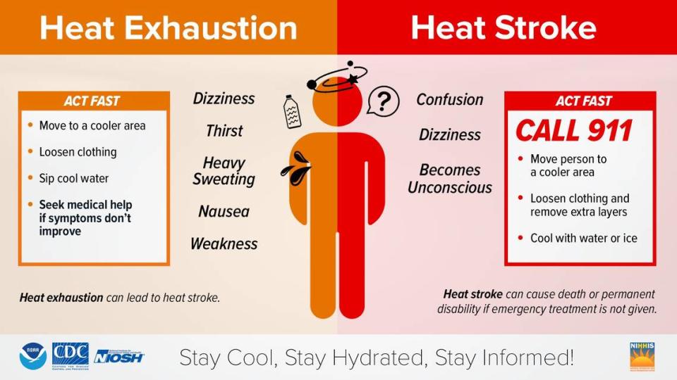
Heat exhaustion
Heavy sweating
Cold, pale and clammy skin
Fast, weak pulse
Nausea or vomiting
Muscle cramps
Tiredness or weakness
Dizziness
Headache
Fainting
Heat stroke
Body temperature of 103 or higher
Hot, red, dry or damp skin
Fast, strong pulse
Headache
Dizziness
Nausea
Confusion
Losing consciousness

