Weekend heat leads to storm chances returning
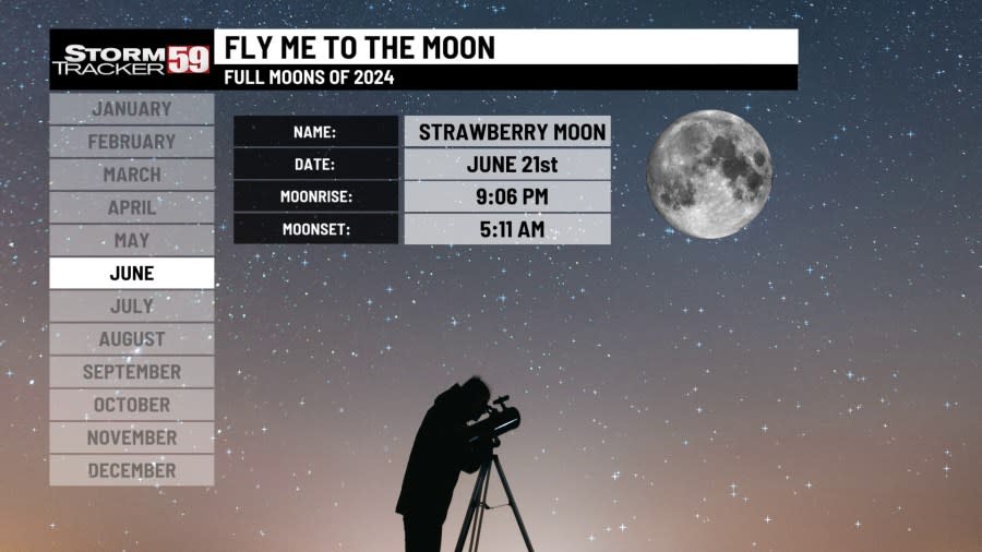
Tonight features partly cloudy skies and temperatures dropping into the mid 60s – pretty similar to what we’ve had the last few nights. The Strawberry Moon is completely full and should be a delight to see with a mixture of middle and high-level clouds around!
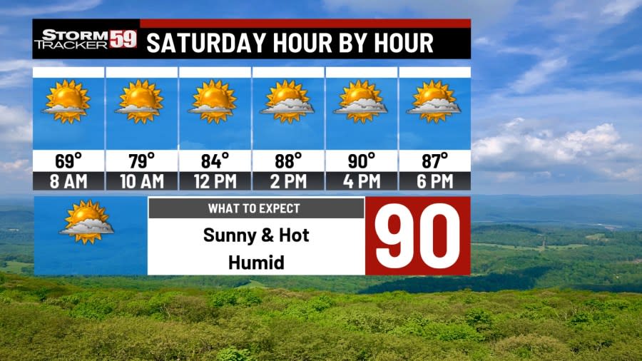
Saturday is a hot day ahead – the hottest expected over the next ten days – as temperatures make a run at 90 degrees under partly sunny skies. A stray isolated shower is possible in the afternoon – mainly in the mountain spots – but most of us will remain dry. Beckley has not reached 90 degrees since June 15th, 2022 – there is a chance we could break that! We still haven’t quite hit 90 yet this year, but we’ve been close! Remember to never leave kids in a locked car unattended, and don’t forget both those that may be sensitive to the heat as well as the pets – provide somewhere to keep them cool, preferably inside if possible! If working outside, make sure to take plenty of breaks and consider adding electrolytes to replace what’s lost in your sweat.
Sunday sees a cold front begin to approach our region during the late afternoon. Although a stray isolated shower is possible in the morning, much better chances for scattered showers and thunderstorms will return by dinnertime and last into the overnight hours as our cold front pushes through. Though most areas will not see much in the way of rainfall, a few towns that see an embedded thunderstorm or two could see very localized heavy rainfall. The Weather Prediction Center has placed our region in a level one marginal risk for flooding – however, with our region being so dry the last couple of weeks, this risk is very low overall. We could use some rain! One or two storms could also provide gusty winds and small hail – the Storm Prediction Center has placed our region in a level one marginal risk for severe weather – this threat is once again very low overall, but we’ll keep an eye on it!

Monday continues the risk for a rumble or two of thunder in the morning before we clear out with high pressure in control for the afternoon. Temperatures will be a little cooler Monday with a northerly breeze kicking in. Humidity levels will drop as well, with highs in the low 80s.

Tuesday features drier air with high pressure taking control. Morning lows in many spots will be in the upper 50s to right around 60 degrees and we will warm to the mid 80s under plenty of sunshine.

Warning signs, symptoms and tips: How to stay safe in the heat
Wednesday sees our chances for showers and thunderstorms return with another front scooting toward the region. It’s a hot and muggy day on the way with storms most likely in the afternoon with highs in the upper 80s.

Thursday features a morning scattered showers and storms with afternoon sunshine and drier weather on the way with highs in the mid 80s.

Severe Weather Awareness Week: Flash flood Safety
Friday provides plenty of sunshine with mostly sunny skies and highs in the mid 80s with high pressure once again in control.
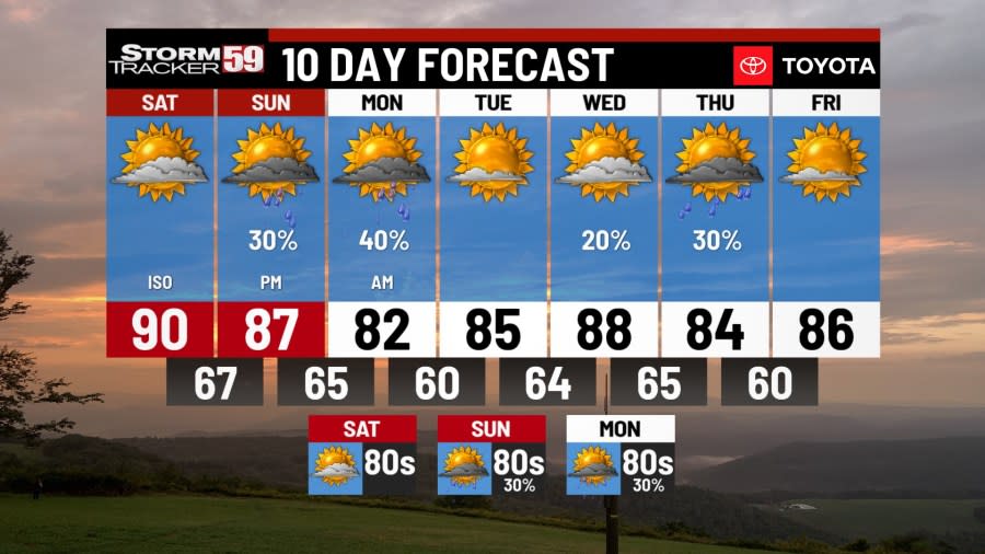
Looking ahead in your extended forecast, the heat continues! Saturday will feature the risk for an isolated shower or storm in the afternoon with heat and humidity as we’ll see high temperatures in the upper 80s. Sunday brings a front into the region with scattered storms likely and highs in the mid to upper 80s. Monday will be cooler with a few lingering showers and highs in the low 80s.

TONIGHT
Mostly clear. Lows in the mid 60s.
SATURDAY
Partly sunny, stray afternoon mountain shower. Hot! Highs around 90.
SUNDAY
Afternoon scattered thunderstorms. Highs in the mid 80s.
MONDAY
Stray storm or two early. Afternoon clearing. Highs in the low 80s.
TUESDAY
Mostly sunny. Highs in the mid 80s.
WEDNESDAY
Afternoon storms. Highs in the upper 80s.
THURSDAY
Few scattered showers. Highs in the mid 80s.
FRIDAY
Mostly sunny. Highs in the mid 80s.
SATURDAY
Isolated storms. Highs in the upper 80s.
SUNDAY
Scattered storms. Highs in the mid 80s.
MONDAY
Isolated storms. Highs in the low 80s.
Copyright 2024 Nexstar Media, Inc. All rights reserved. This material may not be published, broadcast, rewritten, or redistributed.
For the latest news, weather, sports, and streaming video, head to WVNS.

